|
"This chain is singularly barren, but so bold and conspicuous a feature in the landscape claims exploration." (HC Hart, 1895, in I) |
A
Hillwalker's Guide to the Maamturks Ridge Walk, with description, |
 |
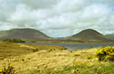
Going towards Leenane, the first climb, onto Corgemore, is a stiff 500+ m. Often there is mist, which makes an interesting problem of the route to Mullach Glas and beyond to the first col lake at Mám Éan. |
|
 |
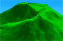
Once atop Binn Chaonaigh you can see onwards to the highest point of the walk, Binn idir an Dá Log. After passing this peak you descend steeply to the second col lake at Maumahoge. |
|
 |
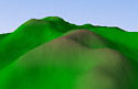
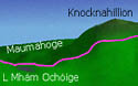
From Knocknahillion to Letterbreckaun is a twisting ridge with ponds and a great view. A stepped descent, sometimes steep, leads then to Maam Turk pass. |
|
 |
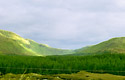
Beyond Maam Turk pass you enter the Northern Turks. Grassy or boggy surfaces and some very steep slopes particularly the long descent to the coast near Leenane. |
|
 |
Safety information, links, maps
compared, routecard, references and information on the model diagrams. There is an
interactive comments section. |
|
Return to Home |
All Photographic and other Material, unless otherwise stated, is Copyright 1993-1999 © Simon Stewart |
|
|
Last changed on 18/03/12 21:11:36 |
||